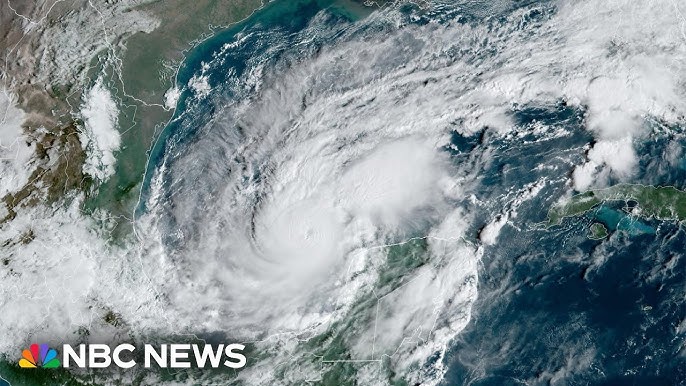
News at six. I’m Alex Michaelson. Thanks for being with us. I’m Marla Tellez. Less than two weeks after Hurricane Helene hit Florida, the state is bracing for another severe storm.
This time, it’s Hurricane Milton, as Hal just mentioned, forecasted to strike the Gulf Coast tomorrow night. The damage is expected to be extensive. Fox’s Rebecca Castro reports live from Tampa. Rebecca, where you are right now, near Tampa Bay, is exactly where people should not be tomorrow night.
We don’t know the exact landfall location for Milton yet. It could be anywhere from the Tampa Bay area to Fort Myers. The region just south of the landfall site will experience the worst impacts, including up to 15 feet of storm surge. This is serious. Safety is paramount as lives are at risk. Hurricane Milton is on a collision course with Florida’s west coast, expected to make landfall overnight Wednesday.
It will then traverse the state before heading out over the Atlantic Ocean. While Milton is not expected to be a category five hurricane, and possibly not even a category four at landfall, the storm will grow significantly in size. Conditions will be life-threatening. The National Hurricane Center forecasts up to a foot of rainfall, 15 feet of storm surge, and potential winds exceeding 100 mph.
Eleven counties, home to approximately 6 million people, are under mandatory evacuation orders. It’s crucial that everyone heeds the warnings and prepares now. Gulf Coast residents are feeling the mental and emotional strain of facing a second hurricane in under two weeks. The situation feels surreal, and people are just trying to keep moving forward.
Many are frightened, unsure of what to expect and when they can return home. Despite the warnings, some residents are choosing not to evacuate. They believe their past experiences with storms have prepared them to stay. Milton is expected to weaken before landfall, but the category number should not be the focus.
Regardless of whether it’s a category five, four, or three, the storm surge threat remains unchanged. Coastal residents need to evacuate for their safety.
The mayor of Tampa has issued a stark warning: if you are in an evacuation zone and choose not to leave, you are putting your life at risk. It appears that the majority of residents are heeding these warnings and evacuating.
However, some people are still in the Tampa Bay area, taking in the views before the storm. Those in higher-level apartments and with cars moved to higher ground feel somewhat secure. But overall, it seems most people are listening to the warnings, as evidenced by the packed roads.
We’ll be live tomorrow night, close to landfall. Our live shot location is a parking garage on high ground. We’ll make decisions on the fly, moving to a hotel if necessary. We have a solid plan in place.
Stay safe, and we’ll see you tomorrow night. Hopefully, everyone gets through this safely.
Now, let’s hear from our chief meteorologist Adam Kruger.
Fox 11 weather, sponsored by your SoCal Hyundai dealers. Rebecca made an excellent point about not fixating on the hurricane’s category. Whether it’s a category five, four, or three, the storm surge will be a significant factor as it makes landfall in Florida. This zoomed-in view of the forecast track will be updated later tonight. Stay with us for the latest stats on Hurricane Milton.
Back in our area, we have one last day of excessive heat warnings in spots like the Coachella Valley and Palm Springs area. These warnings will expire later this evening as temperatures start to cool. No reissuance is expected tomorrow. We’re saying goodbye to the heat alerts.
Temperatures will remain warm this week, slightly above normal. However, cooler temperatures are on the horizon. Futurecast indicates the marine layer’s activity overnight into tomorrow morning, with possible mist or drizzle in some areas. Clouds will retreat from the basin and Orange County in the morning but may return along some beaches by the afternoon.
No major changes or surprises in our seven-day outlook. Temperatures will remain consistent for the next three days: mid-70s on the coast, mid-80s for LA and inland OC, and 90s for valleys and the Inland Empire. Temperatures will begin to drop slightly by Saturday and more significantly by Sunday, leading to a cooler-than-normal pattern next week with mid-70s in Los Angeles.
In the mountains, temperatures will shift from 70s to 60s by the end of the week. The high desert will see a drop from the 90s to more comfortable 80s. The low desert, which has experienced extreme temperatures recently, will remain hot tomorrow, though no excessive heat warning is currently posted.
Read More: Hurricane Milton: 9 p.m. Advisory


